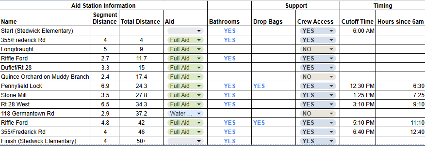
Aid Stations
Stone Mill is known for its amazing aid stations. Each station has dedicated volunteers, different food items, plus water and Tailwind.

** Important note about aid station locations: The GPS coordinates are close, but not perfect. Participants will need to look for the trail crossing. This is especially true on 118/ Germantown Road.
FULL Aid Station - Route 355/ Frederick Road
Location: Miles 4 and 46
GPS: 39.167285,-77.229338
FULL Aid Station - Longdraught (NO CARS!)
Location: Mile 9
GPS: 39.140307, -77.240178
FULL Aid Station - Riffle Ford Road
Location: Miles 11.7 and 42
GPS: 39.133356,-77.268047
FULL Aid Station - Dufief/Route 28 East (Tunnel)
Location: Mile 15
GPS: 39.106703,-77.234488
FULL Aid Station - Quince Orchard on Muddy Branch (NO CARS!)
Location: Mile 17.4
GPS: 39.091966,-77.247448
FULL Aid Station - Pennyfield Lock
Location: Mile 24.3
GPS: 39.056617,-77.293217
FULL Aid Station - Stone Mill
Location: Mile 27.8
GPS: 39.069163,-77.343342
FULL Aid Station - Route 28 West
Location: Mile 34.3
GPS: 39.128196,-77.333166
Aid Station (WATER ONLY) - 118 Germantown Road (NO CARS!)
Location: Mile 37.2
GPS: 39.128396,-77.296972